One of my more frequently visited posts is about how to extract data at point locations in QGIS (see here). In GRASS GIS this can be done with the ‘Sample raster maps at point location’ function. This uploads raster values of one or more raster layers at positions of vector points to user-defined columns in the attribute table.
Below a short explanation how to do this using the menu or command line. In the example I have a point vector layer ‘samples’ and the raster layers ‘precipitation’ and ‘temperature’.
1a) The data of the raster(s) will be written to user-defined columns. Any data in the columns will be overwritten. Often you will want to have the data of the raster layers written to new columns rather than updating existing ones. That means you’ll need to create one column per raster layer:
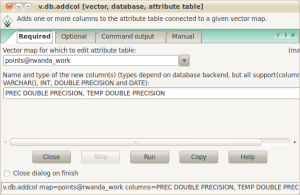
Open the screen using the menu: Database → Manage Databases → Add columns
Or use the command line: v.db.addcol

Select the point layer to upload the raster data and give the name and type of the columns you want to create. In the example above, I created two columns: PREC and TEMP, both with data type DOUBLE PRECISION. Next, click Run and you are done.
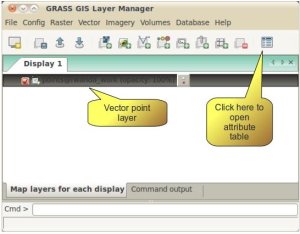
1b) Alternatively, you can open the point layer in the Layer Manager and open the attribute table (Figure 2).

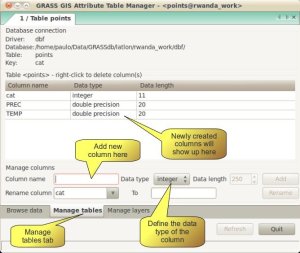
In the Attribute Table Manager screen open the second tab ‘Manage table’ and add the columns in the ‘Column name’ field (Figure 3).

1c) Or, the easiest way, do it all at once on the command line:
v.db.addcol map=points@rwanda_work columns="PREC DOUBLE PRECISION, TEMP DOUBLE PRECISION"
2) To upload the raster values to the attribute table you can use the menu or command line:
Vector → Update point attributes from raster → Sample raster maps at point location
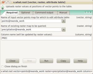
or type on the command line: v.what.rast
This will open the v.what.rast screen where you select the point layer, the name of the raster file to be queried and the column name to upload the raster values to (Figure 4)

Repeat this for all raster layers. Alternatively, use the command line:
v.what.rast vect=points rast=precipitation col=PREC
v.what.rast vect=points rast=temperature col=TEMP
Easy enough, ain’t it :-). Update: if you want to do something similar, but for lines instead of points, see the comments below.

Pingback: Sampling raster values at point locations in QGIS « Ecostudies
Great post pvanb!
I’m looking to do something similar, but using vector lines rather than points. I can’t find an elegant way do to it. Any thoughts? I want (for example) the maximum slope (from a raster) assigned to a road (vector line).
Not sure, but you might want to check v.segment or v.split in GRASS GIS. Both functions allow the creation of points along a line. I just had a quick look, but it seems you can define any distance between points. It requires one more step then when sampling at point locations, but especially if you use it in a script, it should be fairly straightforwards to implement.
There is a plugin in QGIS (profile from line) that does the same, it creates a point file with points along the line(s) at an user-defined distance (using the mapping unit). You can use these points in QGIS to sample your rasters or import the point layer in GRASS using the GRASS GIS toolbox.
The alternative is to convert your line vector layer to a raster, with the same resolution as the raster you want to sample (or you can use a higher resolution, but then you’ll need to resample your raster layer you want to sample too). You can then use a statistical overlay (see raster menu). Make sure to set the region settings to the required resolution first.
I would like to create a loop function using the “for” command to process Worldclim layers, all with similar names (e.g. bio1-19, tmin1-12, tmax1-12, prec1-12). The loop would need to repeat for each iteration:
– adding a column with the layer name (e.g. bio1)
– extracting the data for that layer
– repeat for next layer until iteration limit is reached
I am attempting this now, but would be interested to hear suggestions on how you would process this type of task.
I wrote a small example how to do this in R, see: https://pvanb.wordpress.com/2011/05/04/extract-values-from-multiple-rasters/. Would like to see how you implement this in bash
Update: My script worked a charm and looks like this:
# to create a loop function for worldclim variables with similar naming, use the “for” statement. Construct one loop per variable type (bio, tmin, tmax, prec)
# bioclimatic layers, bio1-19
for i in $(seq 1 19)
do
v.db.addcol map=borneo_geo_pristine columns=”bio$i double precision”
v.what.rast vect=borneo_geo_pristine rast=bio$i col=bio$i
done
#repeated with each variable type
I see our comments crossed in cyberspace :-). Thanks for posting your example. Similar to the R script I posted. One difference is that I first create the columns, but that isn’t that much of a difference I think.
Pingback: Extract values from multiple rasters | Ecostudies
Pingback: Sample raster values at point location in QGIS – yet another way – Ecostudies
This doesn’t work when you import points into GRASS GIS. I don’t know why. Try it yourself by importing some GPS points from a CSV into GRASS. Then try to extract raster values to the points after making a new column to hold the raster data. You’ll get the following error:
No features of type (point) found in vector map…